Council
Elisabete Martins
Deadline Extended | joint RSAI-IGU Conference in Amsterdam in June to February 21
We have extended the abstract submission deadline for the joint RSAI-IGU Conference in Amsterdam in June to February 21. The call with the new date is attached.
ISTH2020. Terms Extension of presentation papers. February 20, 2014
Dear members of the Scientific Committee, accepting some of your suggestions, we considered it appropriate to extend to 20 February 2014 the deadline for submission of papers relating to the Symposium: "NEW METROPOLITAN PERSPECTIVES. The integrated approach of urban sustainable development through the implementation of Horizon/Europe 2020" (ISTH2020).
You can see attached the new Call for papers of the Symposium, with prayer of diffusion.
Thank you again for the scientific contribution to ISTH2020.
Best Regards,
Francesco Calabrò, Lucia Della Spina
Reminder: IRSA 2014 Abstract Submission Deadline, 15 February 2014, 23:59 (GMT+8)
Dear sir/madam,
We would like to remind you that the abstract submission deadline for IRSA 2014 is 15 February 2014 (in the next 5 days). Please kindly submit your abstract via our online submission system at www.conftool.com/irsa2014
We found an alternative cheap travel plan if participants of the 10 World Congress of the RSAI in Bangko are attending Indonesian IRSA conference too. (attached) or visit http://www.makassar2014.irsa-indonesia.org/index.php/venue-travel/traveling-to-makassar
Please kindly visit our official website at www.makassar2014.irsa-indonesia.org or contact local committee via email at This email address is being protected from spambots. You need JavaScript enabled to view it.
Regards,
Yangki Imade Suara (Mr.)
PRSCO 2013 Secretariat
w: www.prsco2013.org
e: This email address is being protected from spambots. You need JavaScript enabled to view it.
Appel à comm Colloque Dimitrie Cantemir ASRDLF Octobre 2014
Cher(e)s adhérent(e)s,
Jean-Paul Carrière, Corneliu Iaţu et Bernard Pecqueur ont le plaisir de vous communiquer l’appel à communication du XXXIVème colloque géographique international « DIMITRIE CANTEMIR », colloque que notre association co-organise avec l’Université Alexandru Ioan Cuza de Iași (Roumanie).
Le colloque aura lieu du 17 au 19 octobre 2014 à Iași (Roumanie), au Département de Géographie de l’Université Alexandru Ioan Cuza, située dans le nord-est de la Roumanie.
Vous trouverez en attaché l’appel à communication.
Vous avez jusqu’au 20 mars pour déposer nos propositions de communications sur le site dédié : http://www.geo.uaic.ro/cantemir/2014/indexcfr.php qui sera en fonction très prochainement
Cordiales salutations
--
Lise Bourdeau-Lepage
Professeure de géographie
Université Jean Moulin - Lyon 3
UMR EVS (CRGA)
18, rue Chevreul
69362 LYON Cedex 07
August Loesch Prize 2014: Submission deadline January 30, 2014
Dear colleague
May I remind you of the announcement of the August Loesch Prize 2014, granted by the city of Heidenheim an der Brenz (Germany) and the August Loesch Association. The submission deadline is January 30, 2014. To meet the deadline, please write, not later than January 30, an E-Mail to
This email address is being protected from spambots. You need JavaScript enabled to view it.
if you would like to submit your work. We will send you further information how to upload your submission. The invitation of submissions is attached. Please forward it to anybody who might be interested.
Johannes Broecker
--
======================================================
Prof. Dr. Johannes Bröcker
Christian-Albrechts-Universität zu Kiel
Institut für Regionalforschung
Tel. +49 431 880 3276
Fax +49 431 880 3363
======================================================
Colloque ASRDLF 2014 - Info 6
Cher(e)s adhérent(e)s,
L’équipe d’organisation du prochain colloque de notre association qui se tiendra du 7 au 9 juillet 2014 à Paris-Est sur le site de la cité Descartes nous informe qu’il nous reste 4 jours (jusqu’au 27 janvier2014) pour soumettre notre proposition de communication.
Les propositions de communications doivent être soumises directement en ligne sur le site du colloque : http://asrdlf2014.org/appel-communications en suivant le lien dans le corps du texte « J’envoie mon résumé ».
Cordiales salutations
--
Lise Bourdeau-Lepage
Professeure de géographie
Université Jean Moulin - Lyon 3
UMR EVS (CRGA)
18, rue Chevreul
69362 LYON Cedex 07
Programme Doctorales ASRDLF 2014
Le comité d'organisation des Doctorales ASRDLF 2014 a le plaisir de vous communiquer le programme et l'affiche de la manifestation qui aura lieu du 3 au 5 février 2014 à la cité Descartes.
Vous trouverez également ci-dessous le plan d'accès aux bâtiments dans lesquels se dérouleront les Doctorales :
http://www.univ-paris-est.fr/fichiers/Acc%C3%A8s_UPE_Descartes.pdf
Pour toute question vous pouvez envoyer un mail à l'adresse : This email address is being protected from spambots. You need JavaScript enabled to view it.
Les informations sont également mises en ligne sur le site de l'ASRDLF : http://www.asrdlf.org/doctorales_ASRDLF.php
18th National Congress of AMECIDER
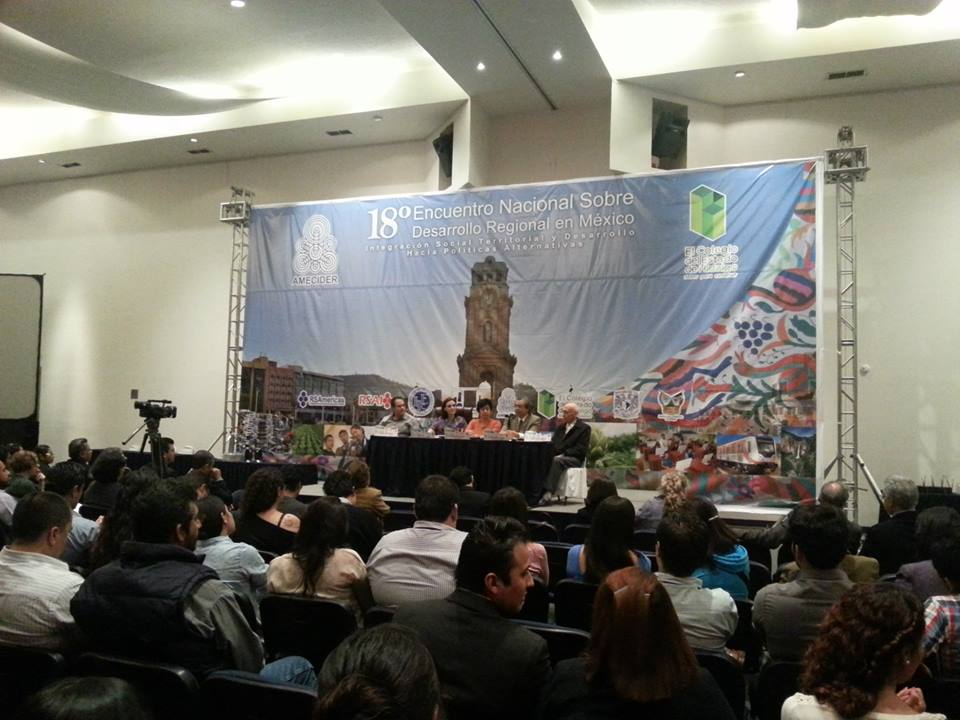
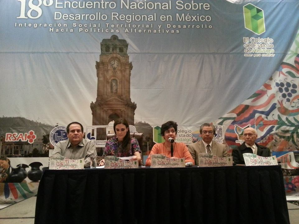
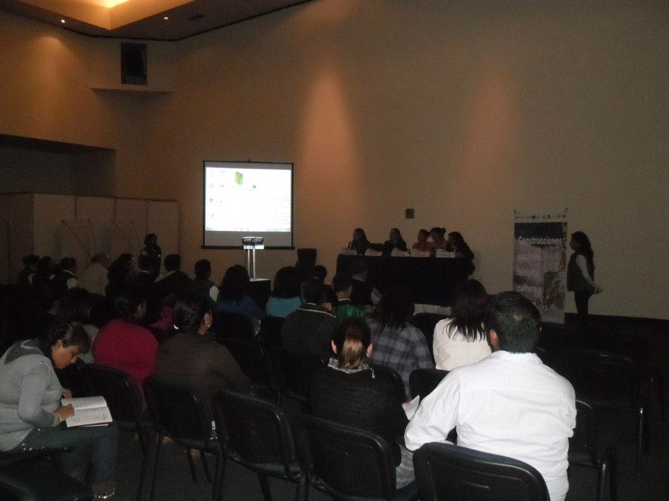
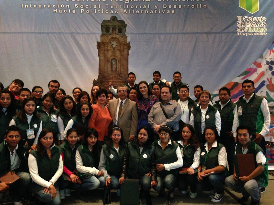
The Mexican Regional Development Science Association (AMECIDER) held its 18th National Meeting in the City of Pachuca (approximately 75kms away from Mexico City), State of Hidalgo, on November 19th- 22nd, 2013. The general theme of the meeting was “Socio-territorial integration and development: towards alternative public policies”. The theme was disaggregated in 12 axial topics that structured the discussion in 45 sessions with selected papers. Altogether, 220 papers were presented, written by 360 authors and coauthors. Together with attendees from the general public, the Meeting had a total attendance of 460 registered participants.
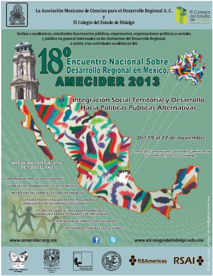
Highlights of the Meeting were: (A) the participation of RSAI President, Dr. Jean-Claude Thill, who shared the Presidium and delivered the keynote speech at the opening session. Besides, he shared important suggestions and advice to AMECIDER members and authorities. His sound scholarship and kind presence were an important stimulus for AMECDER (it incidentally deserved a touching verse in a folksong during a dinner meeting!); (B) the Special Forum for Undergraduate Students on regional issues competing for the “Salvador Rodriguez Award” (in memory of the late AMECIDER President assaulted and killed to steal the Association’s money); (C) each day, besides the parallel sessions, there was one plenary session featuring outstanding national regional scientists addressing key issues of Mexican regions; (D) the event had the firm and highly valued support of the local co-organizer ‘El Colegio del Estado de Hidalgo’ (the Hidalgo State College for Graduate Studies); (E) a special four session forum on local regional issues was organized by the Colegio del Estado de Hidalgo and AMECIDER, gathering a significant and diverse audience; (F) finally, the meeting culminated with the General Assembly in which the election of the Executive Committee of AMECIDER for the period 2013-2016 took place, with Dr. Serena Eréndira Serrano Oswald as new AMECIDER President! Congratulations to her, the first woman AMECIDER-President, and our warmest welcome to the NEW EXECUTIVE COMMITTEE MEMBERS!
 |
 |
||||||||||||||||
| Closing Ceremony | |||||||||||||||||
|
|
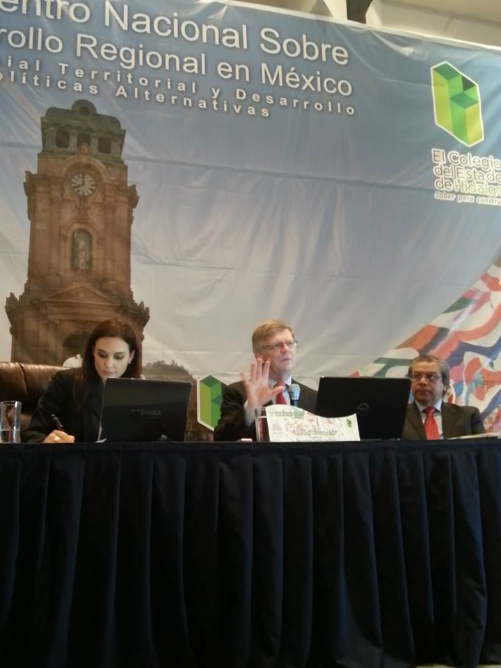 RSAI President, Dr. Jean-Claude Thill
 |
 |
|
| Thematic Axe | Working Session |
 |
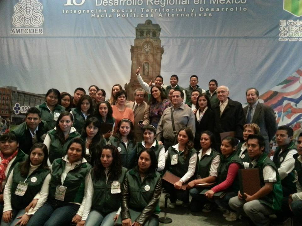 |
| Local Support Team | |
IALE-Europe Thematic Workshop 2014 | 4-5 July 2014, in Instituto Superior Técnico, Lisbon
Call for Abstracts is now open until 15 March 2014!
The first IALE-Europe Thematic Workshop will take place in 4-5 July 2014, in Instituto Superior Técnico, Lisbon. Oral presentations and posters are very much welcomed in each of the following topics:
Symposium 1 – Models and methods: What are the most recent methodological developments? What methods and tools are available? How to define categories for multiple purposes – linking social, economic and environmental processes? How much “simplification” is acceptable? How to best integrate different types of knowledge?
(Organization by Francisco Moreira & Emilio Padoa-Schioppa)
Symposium 2 – Data, variables and indicators: What is the availability of data that can support the selection of variables describing the landscape characteristics? How to derive indicators related with different processes? Are there novel ways of data collection, using technological development and using informal and alternative data sources? How to integrate scale?
(Organization by Sónia Carvalho Ribeiro & Carlos Guerra)
Symposium 3 – Case studies across scales: What is experience is out there? Are we supporting a better policy practice? Can best practices be identified? How satisfyingly do they meet policy needs? Are there recommendations that can be formulated on how to progress?
(Organization by Jorge Gonçalves & Veerle van Eetvelde )
More information at: http://ialeworkshop2014.tecnico.ulisboa.pt/
NARSC Newsletter December 2013
The December 2013 of the newsletter of the North American Regional Science Council is now available -
http://www.narsc.org/newsite/wp-content/uploads/2013/12/NARSCNewsDecember2013.pdf.
The newsletter is posted under the News and Announcement section of the NARSC website -
http://www.narsc.org/newsite/?page_id=417.
Neil Reid, Ph.D.
NARSC Executive Director
About Us
The Regional Science Association International (RSAI), founded in 1954, is an international community of scholars interested in the regional impacts of national or global processes of economic and social change.