Council
Elisabete Martins
Call for papers | "Resensitizing cities: Urban Ambiances and Senses", Rio de Janeiro, Brazil, October 2-5, 2019

Dear colleagues,
Please find attached a call for papers for the conference "Resensitizing cities: Urban Ambiances and Senses" to be held in Rio de Janeiro, Brazil, from October 2 to 5, 2019
The deadline for the submission of full papers is 15 July 2019.
"Resensitizing cities" is an event that integrates the preparatory agenda for the UIA 2020, and will be promoted by LASC / Proarq UFRJ.
The aim of this conference is to investigate the practice of urban daily life and the study of rhythms of life, intertwined with the daily life of cities, on a small scale. Through the look at senses that interfere in uses and appropriations in the urban environment, we intend to deepen the thinking about strategies of articulation between the urban experience and the affectivity in the great metropolis.
The routine of the event includes the presentation of papers and also the accomplishment of experiences in the streets through a central result coming from the workshops of theoretical and practical reflections.
Conference web: https://workshoplasc2019.wixsite.com/ressensitizingcities?lang=en
Feel free to pass this notice on to colleagues and/or students! Thank you.
Cristiane Duarte and Ethel Pinheiro
RESENSITIZING CITIES urban ambiances and senses - october 2nd to 5th, 2019
RESSENSIBILIZANDO CIDADES ambiências urbanas e sentidos - de 2 a 5 de outubro, 2019
The latest issue of Regional Science Policy & Practice are available! Volume 11, Issue 2 Pages 211-442, June 2019
|
|

|
|
Regional Science Policy & Practice Pages: 211-442 June 2019 |

ISSUE INFORMATION
Pages: 211-212 | First Published: 25 June 2019
SPECIAL SECTION: INNOVATION PROCESSES IN RURAL AREAS
Innovation processes in rural areas
Lívia Madureira, André Torre
Pages: 213-218 | First Published: 25 June 2019
Pascal Chevalier, Dominique Vollet
Pages: 219-234 | First Published: 29 November 2018
Governance, institutions and innovation in rural territories: The case of Coruche innovation network
Maria de Fátima Ferreiro, Cristina Sousa
Pages: 235-250 | First Published: 25 October 2018
Shedding light on rural innovation: Introducing and applying a comprehensive indicator system
Teresa Maria Gamito, Lívia Madureira
Pages: 251-277 | First Published: 04 January 2019
André Torre, Etienne Polge, Frederic Wallet
Pages: 279-294 | First Published: 19 December 2018
Innovative capabilities of users of agricultural R&D services
Rosmery Ramos‐Sandoval, José María García Álvarez‐Coque, Francisco Mas‐Verdú
Pages: 295-305 | First Published: 12 October 2018
Rocío Losada, Almudena Gómez‐Ramos, Margarita Rico
Pages: 307-327 | First Published: 16 April 2019
On the trail of local welfare innovations in rural Finland
Niina Rantamäki, Mari Kattilakoski
Pages: 329-343 | First Published: 29 May 2019
OTHER ARTICLES
Measuring the impact of legal and administrative international barriers on regional growth
Roberto Camagni, Roberta Capello, Andrea Caragliu
Pages: 345-366 | First Published: 15 March 2019
John Kibara Manyeki, Balázs Kotosz
Pages: 367-381 | First Published: 20 March 2019
Spatial analysis of factors affecting location decisions of Korean companies in China
Yoomi Kim
Pages: 383-401 | First Published: 25 February 2019
The economic, fiscal, and workforce impacts of coal‐fired power plant closures in Appalachian Ohio
- Jason Jolley, Christelle Khalaf, Gilbert Michaud, Austin M. Sandler
Pages: 403-422 | First Published: 27 February 2019
Rui Alexandre Castanho, Ana Vulevic, José Manuel Naranjo Gómez, José Cabezas, Luis Fernández‐Pozo, Luís Loures, Joanna Kurowska‐Pysz
Pages: 423-435 | First Published: 10 April 2019
BOOK REVIEWS
Anil Hira
Pages: 437-438 | First Published: 29 November 2018
Mark Brown
Pages: 438-440 | First Published: 07 January 2019
The economics of entrepreneurship ‐ By Simon C. Parker
Elizabeth A. Mack
Pages: 440-442 | First Published: 07 January 2019
Research internship at the OECD Trento Centre for Local Development
Dear Colleagues and Friends,
I would like to draw your attention to an opportunity of a research internship at the Spatial Productivity Lab, which is a part of the OECD Trento Centre for Local Development located in Trento, Italy. The application deadline is July 21st. We are looking for candidates with solid quantitative background, god writing skills and interest in regional economic growth.
https://www.oecd.org/cfe/leed/internships-trento-call.htm
With best wishes,
Alexandra Tsvetkova | Economist/Policy Analyst
Trento Centre for Local Development || Spatial Productivity Lab
Centre for Entrepreneurship, SMEs, Regions and Cities
Call for Nominations The William Alonso Memorial Prize for Innovative Work in Regional Science
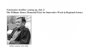
Nomination deadline coming up, July 1!
The William Alonso Memorial Prize for Innovative Work in Regional Science
The William Alonso Memorial Prize for Innovative Work in Regional Science was established in 1999 to honor the memory of a revered, pioneering scholar. In 1960 William Alonso was awarded the first Ph.D. in Regional Science by the University of Pennsylvania. The book based on his dissertation, Location and Land Use (Harvard University Press, 1964), is often credited with launching the field of urban economics. He made numerous major contributions to the study of migration, regional development, and the politics of numbers, and his work ranged from meticulous mathematical theory to far-ranging think pieces. William Alonso was Assistant and Associate Professor of Regional Planning at Harvard University (1959-67), Professor of Regional Planning at the University of California, Berkeley (1966-76), and Richard Saltonstall Professor of Population Policy at Harvard (1976-99).
The objective of the Prize is to recognize the recent innovative research contribution of Regional Science scholars in the spirit of Dr. William Alonso. Previous Prize Winners are:
2002 Masahisa Fujita and Paul Krugman, The Spatial Economy (MIT Press, 1999)
2004 Jacques-François Thisse, Economics of Agglomeration (Cambridge University Press, 2002)
2006 Luc Anselin, Local Indicators of Spatial Association (Geographical Analysis, 1995) Ann Markusen, Sticky Places in Slippery Space (Economic Geography, 1996)
2011 Michael Batty, Cities and Complexity (MIT Press, 2007)
2013 Robert Sampson, Great American City (University of Chicago Press, 2012)
2016 David Boyce and Huw Williams, Forecasting Urban Travel: Past, Present and Future (Edward Elgar, 2015)
Michael Batty, The New Science of Cities (MIT Press 2013)
The next prize is scheduled to be announced in 2019 at the North American Meetings in Pittsburgh.
Nominations for the prize to be announced in 2019 are invited by the Alonso Prize Committee. They may come from any individual or organization including book publishers, university departments, government agencies, and other public or private entities. Each individual or organization is limited to make two nominations for each occasion. The deadline for nominations is July 1, 2019.
- The nominated work must be a book published in 2013 or later. An edited book will be considered only if it is tightly-integrated, not a loose collection of chapters.
- The nominated work may have single or multiple authors.
- Authors are encouraged to self-nominate, and jurors will not know which books were self-nominated.
- Previously nominated books may be re-nominated and will be considered anew.
- To nominate a book (1) send e-mails to This email address is being protected from spambots. You need JavaScript enabled to view it.and This email address is being protected from spambots. You need JavaScript enabled to view it. with citation information, such as William Alonso, Location and Land Use, Harvard University Press, 1964, (2) attach up to three published book reviews, if available, using pdf files. No letters of nomination or support are required, and, if provided, will not be sent to jurors. The selection criteria are innovation and expected impact.
Although occasionally awarded to an article, the Alonso Prize is primarily a book prize. A book’s key idea might have been presented first in a journal article, such as Alonso’s “A Theory of the Urban Land Market,” Papers of the Regional Science Association, 1960, but its fuller development and synthesis with other work can make the book innovative and eligible for the Prize.
Members of the Prize Committee include:
Professor Janet Kohlhase, Chair, University of Houston, This email address is being protected from spambots. You need JavaScript enabled to view it.
Professor Roberta Capello, Politecnico di Milano, This email address is being protected from spambots. You need JavaScript enabled to view it.
Professor Emeritus, Gordon Mulligan, University of Arizona, This email address is being protected from spambots. You need JavaScript enabled to view it.
Professor David Plane, University of Arizona, This email address is being protected from spambots. You need JavaScript enabled to view it.
REMINDER: workshop organised by NECTAR cluster 5
Dear colleague
The call for papers for the Conference "Sustainable Tourism in the Digital World" (24-26 September, 2019), to be held in the beautiful island of Gotland (Visby, Sweden) has been extended until July, 31.
The website of the conference has been updated with information about the preliminary programs and speakers:
http://www.fek.uu.se/research/sustainable-tourism/#anchor-778508
The conference will include a workshop organised by NECTAR cluster 5 (specific call attached) and a “Aim Day”, including a panel discussion with local tourism stakeholders. This will be an excellent opportunity to discuss the practical challenges in destination management for the sustainable development of a small island.
We look forward to meeting you in Visby.
Warm regards,
João Romão
2019 elected RSAI Fellows

RSAI is pleased to announce the election of the following Fellows in 2019:
 University College London, UK
|
 University of Maryland, USA
|
 Université catholique de Louvain, Belgium
|
RSAI Newsletter May 2019 is now online!
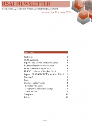
 Dear all,
The new RSAI Newsletter May 2019 can now be found under
https://www.regionalscience.org/images/PDF/Newsletter%202019%20May.pdf
RSPP Call for Paper | Special Issue on Regional Development in Latin-America

Call for papers for RSPP Special Issue on
“Regional Development in Latin-America”.
Dear Colleagues,
The aim of Regional Science Policy & Practice - RSPP is to promote and diffuse the understanding of human interaction in space; based on sound, rigorous and up-to-date methodologies; and focusing on real and urgent issues for peoples and places, that require adequate policy responses.
Latin America has experienced different challenges in this new era that affected many areas of Regional Science: such as migration, trade, economic growth, income inequality, poverty, regional disparity, concentration of economic activity, energy and environment, to mention just some. Therefore, this special issue will feature research (with sound methods and replicable evidence) that sheds light on the different challenges that Latin America will face in the next decades, with a special focus on regional policies which can lead to solve this issues.
The objective of this issue is to provide a better understanding of the regional economic challenges that Latin American countries are facing in the next decades. Case studies from any developing countries will be considered, as well as applied theoretical work.
Submission Guidelines: Interested Authors should send their abstract NLT December 15, 2019 to the editors of this special issue: Rafael Garduño-Rivera This email address is being protected from spambots. You need JavaScript enabled to view it. or Patricio Alessandro Aroca This email address is being protected from spambots. You need JavaScript enabled to view it.
Authors should submit the full papers to the regular review process of the journal until March 22, 2020. The RSPP Editors will select the papers until April 30, 2020. Early submissions are encouraged and will be processed immediately. Papers will undergo the normal refereeing process. The papers will be publish on the third Issue of 2020.
Coordinators of this Special Issue:
Rafael Garduño-Rivera This email address is being protected from spambots. You need JavaScript enabled to view it.
Patricio Alessandro Aroca This email address is being protected from spambots. You need JavaScript enabled to view it.
WORKSHOP & CONFERÊNCIA | 4-7 Junho 2019, Huambo, Angola
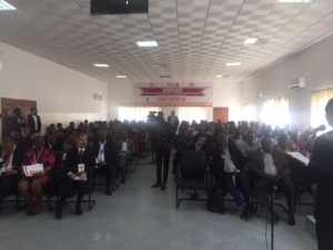
WORKSHOP & CONFERÊNCIA
4-7 JUNHO 2019, HUAMBO, ANGOLA
Workshop sobre Modelos de Economia Regional – um enfoque nos impactos da educação, 4 e 5 Junho de 2019 | Faculdade de Economia da Universidade José Eduardo dos Santos do Huambo, Angola
&
Conferência sobre Os desafios da educação para o desenvolvimento de infraestruturas, governança e sustentabilidade ambiental nos países em desenvolvimento, 6 e 7 de Junho de 2019 | Instituto Superior de Ciências da Educação (ISCED) do Huambo, Angola
Link to WORKSHOP & CONFERÊNCIA
Course on CONTINUING PROFESSIONAL EDUCATION ON DATA ANALYTICS AND SPATIAL ECONOMETRICS, 22-25 July 2019, De La Salle University, Manila, Philippines
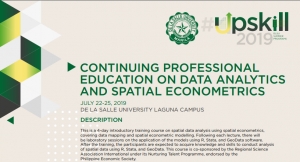
ABOUT THE COURSE
This is a 4-day introductory training course on spatial data analysis using spatial econometrics, covering data mapping and spatial econometric modelling. Following each lecture, there will be laboratory sessions on the application of the models using R and Stata. After the training, the participants are expected to acquire knowledge and skills to conduct analysis of spatial data using R and Stata. This course is co-sponsored by the Regional Science Association International under its Nurturing Talent Programme, endorsed by the Philippine Economic Society.
COURSE OUTLINE
|
Day 1 22 July 2019 |
· Overview on the uses of spatial econometric models in economics and social sciences · Causal models of interdependent outcomes · Strategies for determining appropriate patterns of interconnectedness, geographic patterns of interdependence, and other means of Identifying how neighboring units are socially, politically and economically interdependent |
|
Introduction to Spatial Statistics and Spatial Interdependence |
|
|
Day 2 23 July 2019 |
· Introduction of series of tests that will detect different patterns of spatial interdependence. · Connection of causal relationships on one’s theory to some basic econometric models including the spatial lag, spatial error and spatial-X models |
|
Specification of the Spatial Interdependence |
|
|
Day 3 24 July 2019 |
· Issues of model specification that are unique to these models · Variety of techniques used to estimate spatial econometric models including OLS, MLE and two-stage least squares |
|
Estimating Spatial Econometric Models |
|
|
Day 4 25 July 2019 |
· Calculation and visual depictions of substantive effects from a variety of spatial econometric models · Graphical and tabular techniques to provide meaningful quantities of interest from these models |
|
Visualizing and Depicting Spatial Interdependence |
LECTURERS
|
GIANFRANCO PIRAS, PhD Associate Professor, Economics, The Catholic University of America (https://economics.catholic.edu/faculty-and-research/faculty-profiles/piras-gianfranco/index.html) |
LAWRENCE DACUYCUY, PhD Full Professor and Research Fellow, DLSU-School of Economics President, Philippine Economic Society |
For more information, visit https://www.dlsu-soe.com/dataanalytics.html.
About Us
The Regional Science Association International (RSAI), founded in 1954, is an international community of scholars interested in the regional impacts of national or global processes of economic and social change.