I WAS BORN IN Montbard, a small industrial town in the Côte d’Or, in the French region of Burgundy. The large metallurgical plant, no doubt the distant heir to Buffon’s forges, employed some 2,000 workers at the time, for a population of 6 or 7,000 in the commune. Its importance can still be gauged today by the fact that the TGV high-speed train from Paris to Dijon stops here at least twice a day, putting the small town within an hour of the capital. This major industrial site is the only one to have been created by the main Paris-Lyon-Marseille railway line (which initially passed through Dijon), making its own possible contribution to the theory of the structuring effect of transport routes on the location of economic activities.
At the local level, the town exhibited a very distinctive spatial organisation, a real model of spatial zoning of urban activities and segregation of social categories whose representativeness I would discover later in the scientific literature by sociologists and geographers: the bourgeoisie and shopkeepers in the town centre, on the rocky hillock around which runs the Brenne valley, chosen as their residence by the Dukes of Burgundy as early as the 12th century, and by the naturalist Buffon in the 18th century; the factory, which still manufactures metal tubes, was separated from the town by the Canal de Bourgogne and the railway line; its employees’ homes were built on the southern slope of the valley, with the engineers’ detached houses close to the workplace, a little further up the road the semi-detached houses for the foremen’s families (including my parents’) and at the end of the road the multifamily dwellings for the workers, similar to the “corons” of mining towns. We walked a lot to getfor getting the smallest purchases in the town;, therefore, I covered four times a day the distance of one kilometre and a half to and from the primary school, crossing the railway line and then climbing the hill.
As a child of the baby boom generation, I received a good education at school, encouraged by my parents and the local teachers. My career followed the only possible way open through the national education competitive examinations. Escaping the usual destinies allocated at that time to girls in the small industrial towns, I became a boarder student of the Ecole Normale de Filles that trained future teachers at Dijon. There, I could get fleeting but deep impressions from a beautiful regional capital; I greatly admired the architecture and the traces of Burgundy’s rich past while observing without much using a higher level of urban services. Entering the Ecole Normale Supérieure at Fontenay-aux-Roses was a double chance of getting a first salary and discovering Paris. It took me some time to decipher the most elementary codes of the capital, to perceive the assets of a large city, to measure its power and diversity, and to learn how to take advantage of the metropolitan facilities.
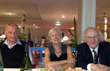
Figure 1 - Prof. Pumain at the 6th European Colloquium on Theoretical and Quantitative Geography that she co-organised with Thérèse Saint- Julien at Chantilly (France) in September 1989. She writes: “Here, I invited Peter Allen (left) and Wolfgang Weidlich (right). The Brussels school of dissipative structures (Ilya Prigogine) and the Stuttgart group of synergetics (Herman Haken) met there for the first time.”
This experience perhaps partly explains my attraction to geography, first as an opening onto the world, then as a scientific discipline. I hadn’t travelled much as a child, but the excursions organised by the ENS to Portugal, Ireland (my first plane trip in 1966), and Italy were excellent introductions to reading landscapes. My curiosity about the regularities of the urban hierarchy was aroused at university by lectures given by Pierre George, Philippe Pinchemel and Michel Rochefort. It was further sharpened during the preparation of a master’s thesis with Marie-Claire Robic on migration to and from French urban areas between 1954 and 1962, under the supervision of Philippe Pinchemel in 1968.
I succeeded with the competitive examination called “aggregation” in 1969, which assured me of a career in secondary education. Still, I had caught the research bug, and a France-Québec grant enabled me to start a post-graduate thesis on the history of geography in Québec. Spending one year in Montreal and discovering geographies other than that of the French school was a rewarding experience. Reading a Master thesis by Leslie King initiated me about the gravity model that would have helped me so much in my previous analyses of interurban migrations; I also learnt there to use computers with software such as Fortran and SPSS. In 1970, I got a job as a lecturer at the Université Paris 1 Panthéon-Sorbonne, which confirmed my vocation for education and research.
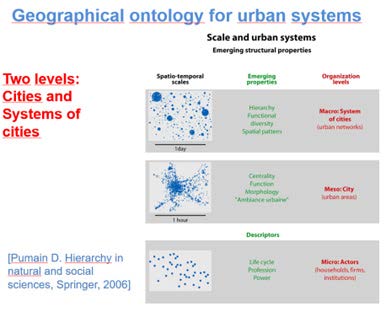
Figure 2 - A multilevel conceptualization of complex urban systems in space and time of social interactions
The main question guiding my research became apparent when I wrote my doctoral thesis (the French “thèse d’État”), which I defended in May 1980. How can we explain the fact that all the well-connected cities in a given area are growing at more or less the same rate and undergoing very similar qualitative transformations in their economies, societies and cultural and material components over decades while, at the same time, all the local people and institutions involved feel that they are taking intelligent, original and autonomous action? How can we overcome this paradox and build a scientific theory to help those involved in spatial planning?
The most comprehensive theory available to geographers and specialists in regional and urban economics at the time was the central places theory. Conceived at a time before the intense phase of global urbanisation that happened in the second half of the 20th century, this theory needed to be supplemented, firstly to take account of the processes involved in locating economic activities that were not solely services to the population (manufacturing, tourism, etc.), and secondly to integrate dynamic processes in order to explain, or even predict, how cities evolve, how settlement systems have been built and why they are so persistent in their hierarchical organisation and functional differentiation.
The question of the scale of observation is essential for theoretical construction. Geographers have long favoured medium-sized scales to understand territories and their evolution. At the time, the data available at the individual level was very scarce or very difficult to access, so I started, through various research programmes and then in collaboration with Thérèse Saint-Julien and PhD students, tobringtogethertheoreticalelements borrowedfromvariousdisciplines and to collect databases that had to be harmonised, on the demographic and economic development of cities in France and Europe, later on in many large regions of the world (figure 2).
A first achievement was to disentangle the huge and sometimes confusing literature about the distribution of city sizes in systems of cities. The “rank- size rule”, as named by Zipf, was a bridge for understanding a structure of inequalities that is common to many open systems. Still, only the stochastic model of urban growth proposed by Robert Gibrat in 1931 offered a convincing statistical explanation that could be tested. This was done in the book called “La dynamique des villes” that I published at Economica in 1982. The statistical description of population growth repartition was a good approximation for coining how urban hierarchies evolve, but the underlining social and economic processes that really explain it had to be specified.
After reviewing the literature on the functional diversity of cities, Thérèse Saint- Julien and I made a first breakthrough by publishing “The dimensions of urban change” in 1978. We explained in this book how the economic profile of cities transformed over time under almost homothetic processes thanks to the spatial diffusion of innovations and how this process could explain the rather long persistency of relative urban functional specialization. We also demonstrated how new specialization could occur when disruptive innovation propagated incrementally among selected subsets of cities that already had the required mix of adaptive assets. Indeed, that work first documented the process that is now called “coevolution” in systems of cities (figure 3).
We mainly used temporal multivariate analysis to process the data at that time. Contrary to economists whom I met in the computer centre of my university, who handled time series, we had to invent methods for comparing cross-sectional tables at successive dates. The validity of our interpretations was more or less ensured by repeating the analyses, comparing different sets of indicators and using statistical tests. On the whole, the principles of the methodology I used to construct the evolutionary theory of urban systems, which I published in 1997, have not changed much: to search for, diversify and harmonise empirical data sets adapted to the questions at stake, to extract information through statistical analysis, to construct models that summarise the regularities in the results, to go into greater depth for interpreting deviations from the models in order to identify geographical specificities and seek to explain them by processes not yet incorporated into the models.
Over the years, I’ve kept a close eye on theoretical developments, trying to understand the possible contributions of disciplines offering concepts and tools useful for formalizing urban evolution. The first of these were statistical methods, multivariate analysis, probability, topology, geostatistics and autocorrelation, a very active group of some 80 geographers who were introduced to annually through continuing education courses from the early 1970s onwards. From an epistemological point of view, I closely followed the development of systemic paradigms. During the 1970s and 1980s, I attended the meetings of the AFCET (Association pour la Cybernétique Economique et Technique). It provided me with essential insights into how other disciplines formulated questions relating to the organisation and dynamics of the objects they dealt with. I have used some of their formulations that I felt could be adapted to geography while striving to go beyond simple analogies to develop explanations that make sense for the human and social sciences.
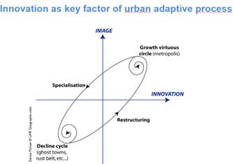
Figure 3. Schematic view of urban dynamics with feedback effects
From 1981 to 1986, while keeping a few courses at University, I had a position as a researcher at the Institut National d’Études Démographiques. I took part in two major conferences in 1981, one at MIT on the “system dynamics” of Jay Forrester and the other one in Brussels on self-organising systems. The concepts of “dissipative structures” and “order through fluctuation” and the epistemological conception of self-organising open systems (including the irreversibility of path trajectories and possibly different qualitative structures produced by the same dynamic quantitative processes) were especially appealing. Because the self-organisation theories described processes exhibiting formal similarities to those we had observed when analysing urban change, I got in touch with Peter Allen in 1982 at a conference about entropy at the University of Créteil. We began a fruitful collaboration with researchers of the Brussels School who were developing models for economics and geography. One of their software, written in Fortran, enabled us to test an economic and spatial development model in four large conurbations that Lena Sanders deeply explored in her doctoral thesis. In fact, Ilya Prigogine prefaced the book “Villes et auto-organisation” that I published with Lena Sanders and Thérèse Saint- Julien in 1989 with the Economica publisher.
At that time, we had already developed regular contacts with the Association de Science Régionale de Langue Française (ASRDLF), and we received the French and English publications distributed to registered members. I sometimes participated in the American and Italian Regional Science Association
congresses. Still, I followed more assiduously the meetings of the European Colloquia on Theoretical and Quantitative Geography (ECTQG), which have been held every two years since 1978 (with Thérèse Saint-Julien we organized one at Chantilly in 1989 (see figure 1). I think I’m the only person to have attended them all, including the most recent one in Braga in 2023. The two-week summer schools funded by NATO and organised by the American geographer Dan Griffith in San Miniato in 1982 and in Hanstholm in 1984 were certainly the most inspiring and fruitful meetings in terms of scientific collaboration.
Figure 4. Awarded the Vautrin Lud “Nobel Prize for Geography” in 2010
In San Miniato, I was very happy to meet many people who are now famous scientists in Regional Science and with whom many further scientific and friendly linkages were developed. (They will forgive me for not mentioning all their names on this short notice, but they are close to my heart). I also started a very fruitful collaboration on urban dynamics models with Lena Sanders, who rapidly got a research position and joined the research laboratory created with the help of the French CNRS in 1984. In Hanstholm, we decided to collaborate with the Stuttgart School of Synergetics, mainly Günter Haag and Wolfgang Weidlich, who developed a model enabling comparisons of the spatiotemporal patterns of interregional migrations in 11 different countries. Lean Sanders wrote in 1992 a book about the application of that model to French interurban migrations that was the start of the series “Villes” by the French publisher Anthropos.
The models consisting of systems of non-linear equations were, however, not flexible enough to deal with the complex and evolving spatial interactions in territorial systems. We soon shifted towards models of multi-agent systems. With the help of computer scientists, we designed the SIMPOP series of models that was conceived to explain the hierarchical differentiation of city sizes and their functional geo-diversity. The implemented mechanisms between “agents” (i.e. collective agents that represent individual cities) are mainly: a proactive and selective propagation of innovations waves generated by interurban competition and emulation; a market exchange between urban functions; a hierarchical selection (top-down and bottom-up); the appearance of new urban functions (exogenous in first models); an expanding range of interurban interaction (as a result of space-time contraction); path dependence according to the territorial boundaries that constrain urban interaction. After 2010, with the ERC programme of the advanced grant GeoDiverCity and a team of PhD students and computer scientists, we developed powerful tools for the exploration and validation of models using genetic algorithms and distributed computing on the OpenMole platform.
Meanwhile, I had a rich and pleasant career that, among other marking events, enabled me to be a co-founder of the research laboratory P.A.R.I.S. (1984), director of the UMR Géographie-cités (CNRS 1992-2000), Chair of the Commission on Urban Development and Urban Life of the International Geographical Union (1992-2000), Director of the European Research Group S4 (Spatial Simulation for Social Sciences, 2006-2013). I am also proud to have been as early as 1996 the founder of the first electronic and open journal in Geography, Cybergeo: European Journal of Geography, whose scientific direction I maintained until 2022. I also had the honour of being nominated as Recteur for the Académie of Grenoble (2000-2001), and I learned a lot about the management of education and territorial politics on this occasion.
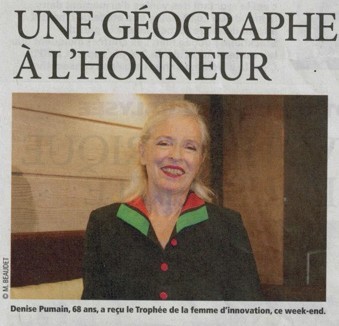
Figure 5. “Femme en or” for innovation in 2014
I feel grateful to the members of the RSAI who have given me the honour of electing me among their Fellows. As a geographer by training, I have found common interests and subjects for discussion with many specialists in French- speaking, Italian and International Regional Science from the start of my career. The interdisciplinary approach to territories has produced remarkable advances in knowledge. I am sure that we shall continue advancing together in the following decades.
Denise Pumain
(Published on RSAI Newsletter 2023 November)