RSAI Worldwide
Elisabete Martins
2021 RSAI Fellows
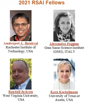
The RSAI Fellows Committee, made up of Prof. Roberto Camagni (Chair), Prof. Kiyoshi Kobayashi, and Prof. Janice Madden, received and evaluated five excellent candidatures for this year's RSAI Fellows election. Thanks to the Committee for carefully reviewing them, and concluding that all were suitable for being voted by the RSAI Fellows, as the rules of this award dictate.
RSAI Fellows then voted, and the following four new Fellows have been elected this year:
- Prof. Amit Batabyal (RIT, USA)
- Prof. Alessandra Faggian (GSSI, Italy)
- Prof. Randall Jackson (West Virginia University, USA)
- Prof. Kara Kockelmann (University of Texas at Austin, USA)
Congratulations to the new Fellows on the outstanding achievement!
Thank you in advance for your attention,
Kind regards,
Congratulations to Prof. Juan Cuadrado-Roura on winning the 2021 ERSA prize
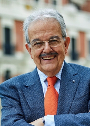
The RSAI joins the global regional science community in congratulating Prof. Juan Cuadrado-Roura, University of Alcalá, on winning the 2021 ERSA prize.
Congratulations Juan!
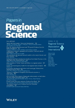
The latest issue of Papers in Regional Science is available! Volume 100, 3 (June 2021)
|
|

|
|
Papers in Regional Science Pages: 603-844 June 2021 |

ISSUE INFORMATION
![]() Free Access
Free Access
Pages: 603-604 | First Published: 10 June 2021
FULL ARTICLES
![]() Open Access
Open Access
Heather Dickey, Alessa M. Widmaier
Pages: 605-631 | First Published: 14 January 2021
Spatial impact of factors influencing the achievement of the Europa2020 employment targets
Jorge Chica-Olmo, Marina Checa-Olivas
Pages: 633-649 | First Published: 11 January 2021
Does social capital reduce entrepreneurs' petty corruption? Evidence across Indonesian regions
Julien Hanoteau, Gandhi Pawitan, Virginie Vial
Pages: 651-670 | First Published: 03 December 2020
Cultural and creative industries and regional diversification: Does size matter?
Gloria Cicerone, Alessandro Crociata, Daniele Mantegazzi
Pages: 671-687 | First Published: 11 November 2020
![]() Open Access
Open Access
Proximity across the distant worlds of university–industry collaborations
Utku Ali Rıza Alpaydın, Rune Dahl Fitjar
Pages: 689-711 | First Published: 24 November 2020
The internal geography of services value‐added in exports: A Latin American perspective
Eduardo A. Haddad, Inácio F. Araújo
Pages: 713-744 | First Published: 18 December 2020
Giovanni Marin, Marco Modica
Pages: 745-775 | First Published: 28 November 2020
Market concentration in the Spanish turbot aquaculture sector: A regional analysis
Raquel Fernández-González, Marcos I. Pérez-Pérez, María Dolores Garza Gil
Pages: 777-794 | First Published: 03 December 2020
Mosquitoes, birth rates and regional spillovers: Evidence from the Zika epidemic in Brazil
Lívia Madeira Triaca, Felipe Garcia Ribeiro, César Augusto Oviedo Tejada
Pages: 795-813 | First Published: 18 December 2020
John R. Hipp, Jae Hong Kim, Benjamin Forthun
Pages: 815-841 | First Published: 12 January 2021
BOOK REVIEW
Amitrajeet A. Batabyal
Pages: 843-844 | First Published: 23 March 2021
Special Issues of RSPP and IIRR-JoRR at the XLVI Regional Studies Meeting - Call for abstracts until Thursday, June 10 (non-extendable)

Dear colleagues,
We are pleased to announce the edition of a special issue of Regional Science Policy & Practice, linked to the International Regional Science Association (RSAI), with the theme of the special session S04 - Territorial inequalities and spatial (in) justice in Europe whose Coordinator is Ana Viñuela.
We also announce a special issue of Investigaciones Regionales-Journal of Regional Research linked to special session 07 - Industry 4.0 and sustainability in regions, clusters & industrial districts whose coordinator is José Hervas-Oliver.
We remind you that the abstract submission deadline for the XLVI Regional Studies Meeting is until Thursday, June 10, 2021 (this deadline cannot be extended so as not to affect the rest of the program dates).
The templates of all the formats of the summary can be downloaded from the website here.
We look forward to your participation and see you soon in Madrid.
Regards,
The Organizing Committee
Spanish Section: Extend submission deadline - 46th AECR Conference, 24-26 November 2021, Autonomous University of Madrid, Spain

Dear colleagues,
Due to the high number of petitions received, we have decided to extend the abstract submission deadline for the XLVI Regional Studies Meeting until Thursday, June 10, 2021 (this deadline cannot be extended so as not to affect the rest of the program dates).
We take this opportunity to remind you that it will be held in Madrid from November 24 to 26, 2021 and that the motto of this edition is “Full cities, empty territories”.
We ask you to disseminate this information to all the people you may consider interested in participating. We remind you that the maximum length is 300 words and will be uploaded through the management area. The presentation of results of research works in progress for which there is not yet a complete article will be accepted. In order for the Scientific Committee to consider the acceptance of said works, an expanded abstract will be required, with a minimum length of 1,500 words. The templates of all the formats of the summary can be downloaded from the website here.
All the necessary information so that you can send your work and register can be found on the website of the XLVI Regional Studies Meeting.
We look forward to your participation and see you soon in Madrid.
Regards,
The Organizing Committee
ERSA Congress registration is OPEN!

|


 Start networking with fellow participants from around the world on twitter
In Memoriam: Prof. R. P. Mishra (1930–2021)
One of India's pioneers in Regional Science, Prof. R. P. Mishra (1930–2021), has passed away
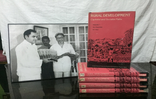
Dr. (Prof.) Rameshwar Prasad Mishra (1930–2021), popularly known as R. P. Mishra, was a notable Indian regional scientist who contributed immensely to the development of regional science in the second half of the last century in India. Prof. Mishra was born in British India, had a double master's degree both in geography and economics, and did his doctoral research at the University of Maryland and was a Fulbright fellow. He along with G.S.Ghosal, and C.R.Pathak provided the second-generation leadership for the development of Indian Geography. He had got the distinct opportunity to do their higher studies in the united states when the discipline had been undergoing through a paradigm shift under the influence of Richard Hartshorne. He, however, could not remain isolated from the changes that the discipline had been undergoing on the account of the positivist-led quantification. His contribution in the early phase of independent India's economic planning with close contact with the Planning Commission of India and other administrative levels made the foundation of the solid economic trajectory of contemporary India. Moreover, His books ‘Regional Planning: Concepts, Techniques, Policies, and Case Studies (1992), Local Level Planning and Development (1998) are the classic textbooks for graduate students in India, inspired many young minds to follow the path of regional planning. Prof. Mishra’s early writings have significantly emphasized the importance of central places and growth poles in the spatial diffusion of development, and as a strategy for the reduction of mass poverty in India. He was also the pioneer to link up the strategy of environmental planning with regional economic planning considering the overall sustainability of the natural environment in the early twentieth century. He also restructured the growth pole theory, especially for newly independent counties in Asia during 1970-80. But, unfortunately, most of his works are now not available in digital forms, and outside India, he is relatively unknown. Apart from his academic contribution, he had a firm belief in Gandhian philosophy, therefore, wrote several books in this area to disseminate his doctrine.
Prof. Mishra was awarded by Bhoogol Ratna (the highest award in the field of Geography in India given by the National Association of Geographers, India); Lifetime Achievement award by the Commonwealth Human Ecology Council; the first recipient of the prestigious National Mahatma Gandhi Fellowship and the Scholarly Achievement Award by the Institute of Oriental Philosophy, Tokyo in 1992. Prof. Mishra worked as Vice-Director, United Nations Center for Regional Development (UNCRD), Nagoya Japan. Between 1984 to 87, he served as Vice-Chancellor of Allahabad University. He was also founding director of the Institute of Development Studies (IDS), the University of Mysore where he closely worked with resource persons from Israel in the diffusion of agricultural technology in India. Finally, Prof. Mishra was always remembered for his wisdom, scholarship and dedication for the expansion of regional science in India.
On the behalf of Regional Science Association, India
Manoranjan Ghosh and Hemant Kumar
 |
 |
||||
|
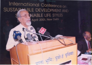
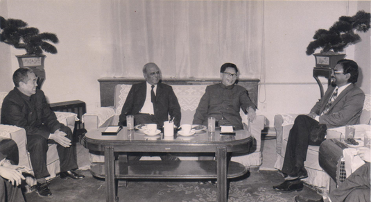
Figure 1: Prof. R. P. Mishra (setting in the extreme right) with international delegations (Source: http://profrpmishra.com/) |
Figure 2: Prof. R. P. Mihsra with former Indian Prime Minister Rajiv Gandhi (Source: http://profrpmishra.com/) |
Vacancy Announcement: Rector of the United Nations University
Organizational Unit: United Nations University Centre, Tokyo, Japan
Reference Number: 2021/UNU/HQ/RO/FTA/R/79015
Applications to: Chair of the Nominating Committee
By Email: This email address is being protected from spambots. You need JavaScript enabled to view it.
Closing Date: 15 July 2021
About the Organisation:
UNU is the academic arm of the United Nations and for the last four decades has been a go-to think tank for evidence-based research on the pressing global problems of human survival, development, and welfare. Fully funded through voluntary-contributions, UNU counts over 400 researchers in 12 countries, and its work spans the full breadth of the 17 Sustainable Development Goals, generating policy-relevant knowledge to effect positive global change in furtherance of the purposes and principles of the Charter of the United Nations. UNU maintains numerous collaborations with UN agencies, leading universities, and research centres. For more information, please visit https://unu.edu
The Position:
The United Nations University (UNU) is recruiting a new Rector. The Rector is the chief academic and administrative officer of the University and has overall responsibility for the direction, organization, administration, and programmes of the University. The Rector is appointed by the Secretary-General of the United Nations after consultation with the Director-General of UNESCO. The position carries the rank of United Nations Under-Secretary-General and requires extensive overseas travel.
Required qualifications:
Advanced university degree, with strong preference for a Ph.D. The successful candidate must have a prominent academic profile with evidence of high-quality research work in the course of his/her career. In addition, he/she will demonstrate an understanding of contemporary development and policymaking challenges and will have experience translating research for policy communities. Demonstrated management experience as the head of a university or research centre is required. Fluency in English is essential.
Desirable qualifications and characteristics:
Established profile in the international community. Experience in managing donor relations and raising funds for organizations. Knowledge, appreciation of, and commitment to the principles and ideals of the United Nations. Capability to maintain close cooperation with individuals, governments, and research institutions worldwide to promote scientific cooperation. Great drive and initiative to achieve the goals of UNU. Demonstrated commitment to gender and diversity issues. Fluency in other official United Nations languages is desirable.
Start Date:
It is expected that the appointee will take up the position on 1 March 2023.
Duration of Contract:
The initial appointment will be for a five-year term, with the possibility of a second term.
Female candidates are strongly encouraged to apply for this position. UNU is committed to achieving gender balance and geographical diversity in its staff. The University has a zero-tolerance policy on sexual exploitation and abuse, sexual harassment, abuse of authority and discrimination.
Remuneration:
UNU offers an attractive package at the Under-Secretary-General level within the UN system, including an annual net salary and post adjustment, which reflects the cost of living in Tokyo. Benefits include 30 days annual leave, dependency benefits, pension plan and health insurance, and applicable additional benefits and entitlements.
Application Procedure:
Interested candidates should email their applications in English to the UNU Rectorship Nominating Committee at This email address is being protected from spambots. You need JavaScript enabled to view it. no later than 15 July 2021.
The application must contain the following supporting documents:
- a cover letter describing how the candidate’s qualifications and experience match the requirements,
- a curriculum vitae,
- a list of publications, and
- a completed and signed UNU Personal History (P.11) form, which can be downloaded at https://unu.edu/about/unu-services/hr/applying-for-a-position#files; please avoid using similar forms provided by other United Nations organisations.
Human rights screening:
Individuals who seek to serve with the United Nations in any individual capacity will be required, if short-listed, to complete a self-attestation stating that they have not committed, been convicted of, nor prosecuted for, any criminal offence and have not been involved, by act or omission, in the commission of any violation of international human rights law or international humanitarian law.
Conflicts of interest:
All United Nations staff members are expected to uphold the highest standards of efficiency, competence and integrity. Senior leaders in particular, have the responsibility to serve as role models in upholding the organization’s ethical standards. Short-listed individuals will also be required to complete the pre-appointment declaration of interests for senior positions to identify possible conflicts of interest that may arise and to proactively prevent and manage, as much as possible and in a timely manner, situations in which personal interests may conflict or appear to conflict with interests of the United Nations, should the individual be appointed to this position.
https://unu.edu/about/hr/academic/rector-under-secretary-general.html#overview
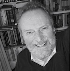
In Memoriam: Ian Masser 1937-2021
 Not only does an obituary provide an event to celebrate achievements of a life but it also provides an excuse to recall amusing anecdotes that say as much about the person as any list of major accomplishments is able to do. Ian Masser was one whose dry sense of humour enabled him to tell great stories about his experiences and keep the listener listening. When he was appointed to the Chair of Planning in the Univers
ity of Utrecht in 1974, he recounted to me the tale of how he got his PhD. He said to me, and I summarise, that when the Chair was advertised, he reasoned that he would never get such a Chair in his own department in the University of Liverpool so he thought he would chance his arm and apply for the position in Utrecht. He said he knew the Chair had been designed for someone else but that someone else did not want the job and that is why he thought he might have a chance. A realist for all seasons was Ian. He was duly interviewed and offered the Chair. He then returned to Liverpool to begin his move. However a few weeks later, he received a letter asking him whether he had a PhD. He did not have one because in those far away days, many people in planning did not have such a qualification largely because planning was still a quite strongly professional subject area, so he replied saying he did not.
A few weeks went by and he received another letter asking him whether he could get one – a PhD, because in the Netherlands professors had some sort of higher degree, the particular form of which was lost on we British. And it was clear the authorities in the Netherlands didn’t understand the British University system either. In those days, there was no email and the telephones didn’t work that well and what complicated matters was that at every stage of the process of appointment, the position and the candidate had to be checked by the Palace in Amsterdam. The appointment had to be signed off by the Head of State. So as Ian recounted it to me, once a letter came to Liverpool, the reply was sent back to Queen Juliana of the Netherlands for approval. As Ian wryly joked, a messenger bearing the royal seal was involved at every stage, a soldier on horseback! When Ian received the letter more or less suggesting that he acquire a PhD, he replied saying he thought he could do so. This to most Brits was then truly amazing. In fact in only about 6 UK universities in those days, could you get a PhD by submission of publications and Liverpool was one such place. So he set about putting his publications together and binding them into a coherent bundle, submitting the material, which was duly examined, gaining the coveted degree. At this point, a year had elapsed from the time he had been offered the job but when he then took up his post, he found out that he was supposed to teach in Dutch by the time the year ended. In fact he painfully struggled with courses while his wife picked up the language in five minutes in the supermarket (Liverpudlian’s are great linguists!). I am sure the stories are apocryphal but Ian’s experience of getting a PhD later in life was not so unusual as this obituarist well knows. I did the same at Cardiff in the early 1980s although I had to go through the real motions and register formally. Ian of course was one of my external examiners.
There is much about Ian that I could tell you of his career but Peter Brown who has penned some personal reflections following this will say more. I first met Ian in the University of Manchester in the Department of Town and Country Planning in 1967 where a small workshop was being convened on new techniques in planning. Ian was then a Lecturer in Civic Design in the University of Liverpool and I a Studio Assistant with duties in project teaching Both of us however saw our main focus on the development of computer models of land use and transport which were taking the planning world by storm in the 1960s. This was the decade of the systems approach, the time when planning threw off its mantle of the bureaucracy that had fashioned a planning system based largely on aesthetic design to one which began to think of cities and their planning as systems to be controlled. Models were central to this focus and as soon as we met, Ian and myself became kindred spirits in the advance of this cause. In that year, he suggested that we offer a short course on what urban land use transport models could do and he set up a series of three evening talks in Liverpool in the School of Civic Design where we both laid out what this new focus was all about. He produced the lecture notes for this which gained quite wide circulation at the time. In fact he was the first to produce a small textbook called Analytical Models for Urban and Regional Planning (1972) that established the work of the group he was building up at Liverpool (and which has continued there in various guises ever since).
Ian’s research then began to move from models to data and he really spent the rest of his life dealing with data and spatial infrastructure to enable planners to use different data. He moved from Utrecht back to the Chair of Planning at Sheffield University in 1978 where he was Head of Department for some years. In the 1980s, he became increasingly interested in data, first becoming coordinator of the ERSC Regional Research Labs (RRLs) Initiative which then seamlessly morphed into the European Science Foundation GISDATA project (Geographic Information Systems + Data) which brought together a network of centres. He worked with Max Craglia on this project and although I did not know him so well at Sheffield – I moved to the US in 1990 – we collaborated between the SUNY-Buffalo site of the NCGIA I was directing there (the National Center for Geographic Information and Analysis) and the ESRC’s RRL and then GISDATA projects. Ultimately this collaboration was to lead to the Vespucci summer school lectures held In Florence in the 2000s. On the back of GISDATA, Ian was responsible for forming the European network of GIS centres called AGILE and he was also instrumental in supporting the AGI in building a robust organisation. Peter Brown talks a little of this below but Ian moved back to Holland in 1998 to run the planni
It is easy to forget that Ian was first and foremost trained in planning at a time when our views about cities were not particularly abstract but nevertheless highly visual. His early papers in the Town Planning Review, the first of which was on village design in metropolitan hinterlands in 1965, indicate his broad perspective on planning and design. When we cooperated in the 1970s on papers, we both expected our work to be useful to planners, notwithstanding the enormous challenges in translating this kind of knowledge into planning practice. This was a central theme in Ian’s long standing contributions and I will remember his patience and perspicuity in dealing with the challenges of building a more scientific approach into how we need to make our cities more sustainable and liveable.ng school at ICT from which he retired in the early 2003. Ian spent a lot of time in his later years working with spatial data infrastructure producing an influential and cogent paper with Michael Wegener in 2016 in this journal “Brave New GIS Worlds Revisited”, Environment and Planning B: Planning and Design, Vol. 43(6), 1155–1161 which looked back 20 years to 1996 at which time GIS was focussing on spatial data infrastructure much of which has now been built. His last book Building European Spatial Data Infrastructures (Esri Press, 2015) as as good a summary of this perspective on the field of spatial infrastructure as you will find.
Michael Batty, University College London
RSAI Newsletter (May 2021)
Dear RSAI members,
I hope this email finds you well.
I am writing you as the 13th World Congress just opened (yesterday) with an intense first day, packed with two excellent keynote lectures and 35 sessions, including both regular, national, and special ones. To this starter we are adding today a first dish with 40 more sessions, another much expected Keynote Speech, by Prof. Siqi Zheng (MIT), and a full day of Regional Science Avademy activities. I hope those of you who decided to join the congress will have as much interest in these events as I personally had throughout yesterday.
I am also happy to take the chance to send you the May 2021 issue of the RSAI newsletter (download), as usual skillfully edited by Prof. Martijn Smit (University of Utrecht). Martijn is seeking a second pair of eyes to help with both the gathering of contributions, and the proofreading of the final product. Applications from the global South or from those with a good range of contacts there would be particularly welcome, as would being a native speaker of English. Please contact Martijn at This email address is being protected from spambots. You need JavaScript enabled to view it. within Friday 23 July 2021 if you’re interested, enclosing a CV and a half-page statement of purpose, indicating why you feel you’re a good fit for editing the newsletter and how involved you have been and plan to be in RSAI and its activities.
To all members, a very fine day; and to the World Congress participants, best wishes of an interesting day, with lots of learning and interactions.
Kind regards,
Andrea Caragliu
Associate Professor of Regional and Urban Economics
Politecnico di Milano, ABC Department
RSAI Executive Director
About Us
The Regional Science Association International (RSAI), founded in 1954, is an international community of scholars interested in the regional impacts of national or global processes of economic and social change.