Elisabete Martins
Call for Papers - IRSA 2014
|
Political Economy of Regional Development in Indonesia |
|
|
The Indonesian Regional Science Association (IRSA) in collaboration with Hasanuddin University invites scholars, practitioners and graduate students to submit papers to be presented in the 12th Indonesian Regional Science Association (IRSA) Conference in Makassar, South Sulawesi, on June 2-3, 2014 and theme of the conference is Political Economy of Regional Development in Indonesia.
Potential topics to be discussed in this conference include, but are not limited to:
Extended paper abstract of about 300-500 words should be submitted online via IRSA 2014 conference website. Abstract should consist of background, data and methodology, and potential contribution to knowledge. Please provide keywords and JEL number. Abstract should be in English, as also the full paper.
The deadline for abstract submission is 15 February 2014. Those whose abstracts accepted should submit their full papers by 15 April 2014 and register to attend the conference by 20 April 2014 in order for their paper to be included in the final program.
The conference will have four prominent scholars and experienced practitioners as keynote speakers. Among others are Prof. Armida Alisjahbana (Padjadjaran University / Minister of National Development Planning), Prof. Iwan Jaya Azis (Cornell University / Asian Development Bank), Prof. Anne Booth (SOAS, University of London), and Prof. Ari Kuncoro (University of Indonesia). Paper sessions are seminar-style with a discussant for each paper and time for discussion and for participants to provide constructive feedback to authors. Paper presentations will be in English.
Makassar also a gateway to Eastern part of Indonesia and entry point to an adventurous tour to the Tana Toraja highlands, deep in the fertile plateaus of Sulawesi, or also known as Celebes. The unique Torajan culture, including their animistic burial rites call it Rambusolo, makes this region one of the most fascinating wonders in Indonesia. Your visit will be a memorable one.
We look forward to seeing you in Makassar, Indonesia
IRSA 2014 Secretariat |
|
|
Important Dates |
Plenary Speakers |
Regards,
Yangki Imade Suara
PRSCO 2013 Secretariat
w: www.prsco2013.org
e: This email address is being protected from spambots. You need JavaScript enabled to view it.
PRSCO 2013 : Download your Photo(s) via our Flickr Account
Our photographers took a lot of pictures during PRSCO 2013 (around 30 GB in total). We have uploaded all pictures to IRSA's Flickr account. Please kindly visit http://www.flickr.com/photos/irsa-indonesia/sets/ to download your pictures during PRSCO 2013.
If you have uploaded your pictures to Flickr, please kindly use tag #prsco2013 and #irsa2013 so we can link it with our photo album.
Regards,
Yangki Imade Suara
LOC PRSCO 2013
e: This email address is being protected from spambots. You need JavaScript enabled to view it.
--
The 23rd PRSCO and the 4th IRSA Institute http://www.prsco2013.org/ | https://www.conftool.com/prsco2013/
Semin. "Governance, Science and Innovation in Development Policies" - 14 Jan., U. Aveiro
No dia 14 de Janeiro de 2014, terá lugar na Universidade de Aveiro, Sala de Atos da Reitoria, entre as 9:00 e as 18:30, o seminário internacional “Governance, Science and Innovation in Development Policies”, organizado no âmbito do projeto “Alianças Territoriais para a Inovação”.
O seminário será estruturado em torno de dois temas principais: “Leadership for Governance: Much Ado about Nothing?”, a ser debatido durante a manhã, e “Science, Development Policy and the Stubborn Reality!”, que constituirá o motivo de debate durante a tarde. A estimular e apoiar os debates estarão os oradores Gerry Stoker, Colin Copus, Giovanni Allegretti e Luís de Sousa no primeiro tema, e Bjørn Asheim, Louise Kempton, John Edwards, e Paulo Pinho no segundo. Poderá consultar mais informações sobre o evento no programa que enviamos em anexo.
O seminário, de inscrição gratuita, terá um número limitado de participantes. Teríamos muito gosto em poder contar com a sua presença. Ficaríamos gratos se confirmasse a sua participação para um dos seguintes e-mails: This email address is being protected from spambots. You need JavaScript enabled to view it. ou This email address is being protected from spambots. You need JavaScript enabled to view it..
Para qualquer informação adicional, não hesite em contactar.
--
Saudações cordiais,
A Coordenação da Equipa do Projeto “Alianças Territoriais para a Inovação”
Artur de Rosa Pires
Filipe Teles
CALL FOR PAPERS | 22nd International Input-Output Conference, 15th – 18th July, 2014, Lisbon, Portugal
'Call for Papers' for the 2014 IIOA Conference in Lisbon, Portugal (15-18th July 2014). (See the Call document attached!)
Our Conference Paper Submission System (COPASS) is open to receive your abstracts (and full papers). Goto: https://copass.iioa.org, login, and click the link "22nd IIOA Conference in Lisbon".
We are looking forward to your participation!
Check out latest news, important dates, accommodation hints, and how to contact us on the conference web-page: http://www.iioa.org/conferences/22nd/
International Conference on E-commerce and Contemporary Economic Development [ECED2014] -Call For Paper-EI/ISTP indexing
2014 International Conference on E-commerce and Contemporary Economic Development [ECED2014] aims to bring together researchers, engineers and students from around the world in both fields about E-commerce and Contemporary Economic Devel opment for information sharing and cooperation. Researchers and practitioners are invited to submit their contributions to ECED2014.
Thesis topics
- a) Business And Social Applications;
- b) Communication And Network Security;
- c) E- Business And Extended Issues In E -Business;
- d) Innovation Management and International Finance.
Note: Not limited to the above issues. The authors according to the above issues can personally giving their comments and opinions
The paper language: English
Index: EI and ISTP
Paper format
- a) All submissions must be original, unpublished, and not submitted concurrently for publication elsewhere.
- b) Each paper should be at 3 pages
- c) Finally leave our E-mail convenient we contact you.
Paper submission Due: March 08, 2014
Conference Date: June 7-8,2014
Conference Location: Hong Kong, China
The official website: http://www.eced2014.com
Submission Via Email: This email address is being protected from spambots. You need JavaScript enabled to view it.
ECED2014 ORGANIZER COMMITTEE
Conference «Region-2014», «Journal of Human Geography», the monograph on human geography, issues on cooperation
Dear colleagues!
The Department for Social and Economic Geography and Regional Studies, the Faculty of Geology and Geography, V.N. Karazin Kharkiv National University (Ukraine) invites you to take part on 3-4 April, 2014 at the scientific and practical conference for students, post-graduate students and young researches «Region-2014: human-geographical aspects» and to publish your articles in the scientific journal «Journal of human geography». The call for papers is placed in the attached file.
http://hgj.univer.kharkov.ua/index.php/en/ – the link to the web-site of our journal. The journal is included in the list of Ukraine’s scientific professional publications (according to the Certified Staff Evaluation Department of the Ministry of Education and Science of Ukraine), which results of theses for the degree of Doctor of Philosophy (geographical sciences) may be published.
In 2013 the monograph “Spatial Analysis in Human Geography: New Approaches, Methods, Models. Monograph / K.A. Nemets. – Kharkiv: KhNU, 2013. – 225 p.” by K.A. Nemets, L.M. Nemets was published. («Просторовий аналіз у суспільній географії: нові підходи, методи, моделі»)
In the attached file the content and the summary of the monograph are placed.
Also I suggest to look through the research interests of the Department for Social and Economic Geography and Regional Studies. The department deals with such issues: evaluation of natural resource, tourist resource potential and environmental management, demographic studies, investigations of the employment potential, analysis of the social infrastructure, social development, social safety of territories, studies of business environment, small and average entrepreneurship, studies of foreign economic connections of border and cross-border territories, territorial organization of the agricultural complex, training of specialties (masters) in recreation and excursion activity. Methodic of the study of the territorial planning, and monitoring model of the city's social and economic development have been worked out by the researchers of the department. If some of these fields of research are intersected with yours we would be glad to collaborate.
If you have any questions, please, write to my e-mail (This email address is being protected from spambots. You need JavaScript enabled to view it., This email address is being protected from spambots. You need JavaScript enabled to view it.) or listed below:
This email address is being protected from spambots. You need JavaScript enabled to view it. (the e-mail for questions on articles in «Journal of HUMAN geography»)
This email address is being protected from spambots. You need JavaScript enabled to view it.(E-mail for submission papers at the conference «Region-2013: Human- geographical Aspects»
The e-mail of the Department for Social and Economic Geography and Regional Studies, the Faculty of Geology and Geography, V.N. Karazin Kharkiv National University (Ukraine):
This email address is being protected from spambots. You need JavaScript enabled to view it.
The web-site of the department:
http://soc-econom-region.univer.kharkov.ua/index.php?lang=en
We are waiting for your publications and look forward to working!
Sincerely, Pavel Kobylin.
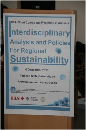
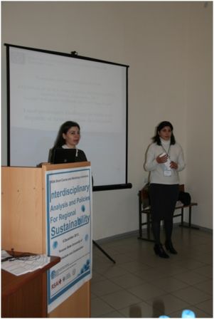
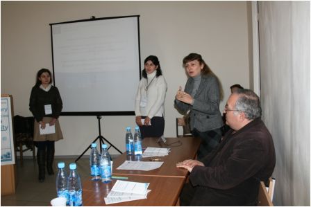
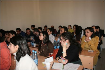
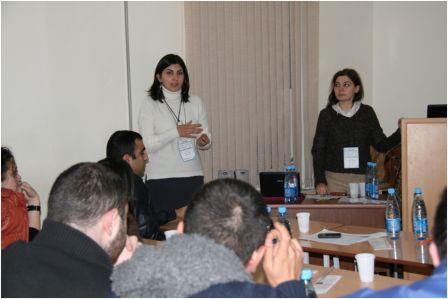
The RSAI Workshop in Armenia, December 2013

With the support of Gulbenkian Foundation, and with the aim to create a Regional Science Association International (www.regionalscience.org) Section in Armenia, took place on the 6th of December 2013, at Yerevan State University of Architecture and Construction (www.ysuac.am ) a Regional Science Workshop on Interdisciplinary Analysis and Policies for Regional Sustainability. There were seven speakers and thirty participants. The remaining of the support will be spent in a Conference by Peter Nijkamp on March 2014 and on support to Armenian scientists in the European Regional Science Association Conference that will take place on August 2014 in Saint Petersburg, Russia.
AESOP Annual Congress 2014: From Control to Co-evolution
Only 6 DAYS left to submit the abstract.
List of tracks and online abstract submission are available here.
IEOM 2014 Conference and Global Engineering Education - Details Final Program
Dear Colleagues:
You still have time to join us in Bail, Indonesia at the 2014 international industrial engineering and operations management (IEOM) conference on January 7-9 and meet people from more than 60 counties including distinguished global engineering education speakers. IEOM 2014 conference program is attached.
If you are interested, you can register onsite at Grand Hyatt Bali. The early registration will open on Monday, January 6 from 3:00 pm to 9:00 pm in the Grand Ballroom Foyer area. The regular registration fee includes: conference technical sessions, keynote presentations, global engineering education sessions, welcome reception, conference award dinner and cultural program, box lunches (Tuesday and Wednesday), coffee breaks, conference program booklet, conference CDROM proceedings and conference bag.
You will see a great added value conference. Your participation of IEOM 2014 Bali Conference is highly appreciated.
IEOM Forum wishes you a HAPPY AND PROSPEROUS NEW YEAR!
Thanks
Ahad
-----------------------------
Ahad Ali, Ph.D.
Conference Chair, IEOM 2014
www.iieom.org
Job Possition | The Universidad Católica del Norte is recruiting two associate professors
The Universidad Católica del Norte (www.ucn.cl), Department of Economics is recruiting two associate professors for researching and teaching activities.
We invite to apply Doctors and PhD in Economics and Geography. We will specially value the knowledge in the fields of regional economics, economic geography, urban economics, natural resources economics and economic development. The position requires a medium level of Spanish language. The applicant must 1) contribute to graduate-level teaching; 2) teach undergraduate courses; 3) ability to develop and maintain an externally funded research program; 4) ability to contribute to the department’s interdisciplinary mission.
It is expected that the candidate will be available to start working preferably in March, 1st 2014.
Required qualifications: 1) a full curriculum vita, 2) a doctoral degree closely related to the fields above describe at the time of appointment, 3) letter of application describing research and teaching interests, 4) samples of writing or publications and 5) the names and contact details of two referees plus the recommendation letter
Applications will be accepted until the positions are filled.
Any question about the application process must be sent to Dusan Paredes, Tel. 56 55 2355746, This email address is being protected from spambots. You need JavaScript enabled to view it.
About Us
The Regional Science Association International (RSAI), founded in 1954, is an international community of scholars interested in the regional impacts of national or global processes of economic and social change.