MAPS AND ATLASES always fascinated me as a child, even if I would have loved (and still do!) to be an English/Dutch schoolteacher! I chose geography instead of philology because I perceived very early that geography was a science at the crossroad of many other disciplines, not too specialized but challenging enough and dealing with societal and environmental issues … and foreign languages could also be useful! I now think that I took the right decision!
From the very beginning of my research career, I was oriented to quantitative analyses and modelling by my promoter/supervisor Hubert Beguin. He almost forced me to do a PhD and decided for me that it would deal with optimal locations, using operational research models and applying them to real-world situations (in my case post-offices). This was quite novel at that time.
After a fruitful Post-doc period, there was unfortunately no academic positions available that were compatible with my family constraints so I left the university for a quite unusual and challenging position: scientific collaborator at the Gendarmerie Headquarters (Brussels). We were a team of two geographers hired as civilians to work in a military environment, two women in a work environment where officers were still men only: an adventure! Our mission: to provide support with geostatistical tools, maps and models. I was in charge of road accidents, my colleague of criminality. Where do accidents occur? Why there? What is the best location of police patrols? What is the optimal partitioning for police districts? This was a period where I learned how to use geospatial techniques or models, and present their results in layman’s terms, showing the usefulness of geography in operational decision making. I think most academics would gain from working for a while out of the academic world: such an experience helps enormously in teaching or in writing multidisciplinary research projects.
After this unconventional experience, I came back to university with a FNRS permanent research position at the Department of Geography in Louvain-la- Neuve (Be) where I mainly conducted research in economic and transport geography, and additionally taught several courses such as statistical cartography, transport or economic geography and gave tutorials on thesis preparation. I also wrote a second doctoral dissertation on the sensitivity of location-allocation models to transportation issues. I later moved to the Center of Operations Research and Econometrics (CORE), an internationally well-known scientific research centre, where I was the only geographer among mainly economists, operational researchers and engineers.
Now more than ever I feel rich and stronger for those multidisciplinary research experiences. I’ve particularly appreciated to work at the border of my discipline. I’ve engaged with very nice and openminded researchers with whom I have exchanged ideas and published. Not only geographers of other universities/ countries, but also economists, physicists, engineers, epidemiologists and medical doctors. Constructing a scientific project or publishing together is for sure not an easy task: we think differently, we’ve other priorities, we refer to other models/theories, and even write our scientific papers differently. But what satisfaction when we succeed in respecting each other, taking advantage of our complementarities, constructing new ideas and realizing in fact that we deal with the same questions but with different words, tools or theories.
 Quantitative geography has a great future especially in regional sciences. Geography has always dealt with locations, large data sets or nested scales and has accumulated knowledge, even if geographers are often shy in putting this forward. Geography is hence now more than ever ready to deal with topics such as complexities or “big data”. Small or big, new data types appear every day: sensors become censors in the new smart environments. Geographers know better than any other researcher that spatial data are special… Big data do not change fundamentally the problems; there is no need to reinvent the wheel: aggregation biases, close things are more related than distant things, statistical biases, etc. It seems that nowadays I too frequently read papers that simply let the data speak by themselves, without any caution. I hope to have time in the coming years to further work on these topics, to fight with geographical tools against data bulimia and theory anorexia, to help machine learning researchers in further constructing meaningful models that do not reinvent geography but push forward their results into further models and theories.
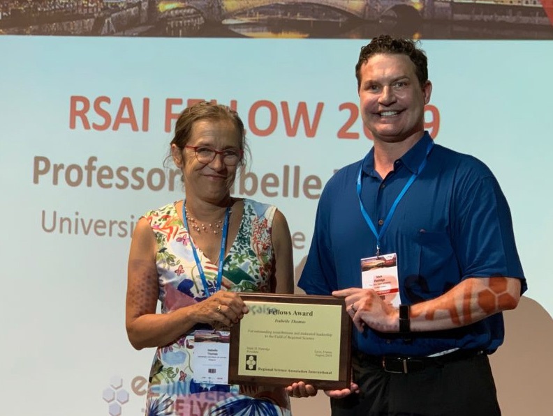
I’m so happy and proud as a geographer to be awarded the RSAI Fellowship. I never aimed for it, but it happened in 2019 (pictured on the left, with prof. Partridge). I’m simply enjoying the moment!
Isabelle Thomas
Research Director at the National Fund for Scientific Research (FRS-FNRS) Extraordinary Professor, Université catholique de Louvain, Louvain-la-Neuve (Belgium)
(Published on RSAI Newsletter 2020 May)